探索AI在地质科研绘图中的应用:ChatGPT与Midjourney绘图流程与效果对比
文章目录
- 个人感受
- 一、AI绘图流程
- 1.1 Midjourney
- (1)环境配置
- (2)生成prompt
- (3)完善prompt
- (4)开始绘图
- (5)后处理
- 1.2 ChatGPT
- 不合理的出图结果
- 解决方案
- 二、主题绘图结果展示
- 地球内部圈层
- 史前时期地貌演化模式
- 不同时期化石演化
- 板块运动
- 地质活动
- 地层褶皱
- 地震
- 海啸
- 雪崩
- 火山喷发
- 岩浆流动
- 冰川地貌
- 河流地貌-细小河流汇聚
- 河流地貌-河流穿过树林
- 河流地貌-上游至下游
- 河流地貌-河间地块
- 喀斯特地貌
- 风化侵蚀
- 水循环
- 土壤剖面1
- 土壤剖面2
- 土壤质地方块
- 孔隙含水介质
- 油气开采
- 卫星遥感
- 水库
- 地面沉降
- 三、出图效果对比
个人感受
AI擅长的主题 + 好的prompt + 局部重绘 + 后处理 = 好的出图效果
AI出图效果的好坏强依赖于prompt(提示词),直接根据某个宽泛的主题出图的效果通常很差,部分公众号等媒体在宣传中往往夸大了AI在科研绘图中的作用。
AI技术能够生成具有氛围感、真实感和艺术性的插图,作为科普插图是足够的。


然而,目前AI生成的插图在精确性、可控性和科学规范性方面仍存在一定局限,因此难以直接应用于严谨的科研论文插图中。


一些比较满意的出图
【风化侵蚀】

【冻土退化】

一些效果差的出图,缺乏逻辑


一、AI绘图流程
1.1 Midjourney
(1)环境配置
环境配置流程
- 开通会员账号/租共享账号
- 安装discord
- 创建服务器
- 添加Midjourney Bot至群组
- 用/imagine命令开始绘图

(2)生成prompt
方式1:用Midjourney的/describe命令

方式2:上传图片至chatgpt生成绘图所需prompt
假如我想生成几乎一模一样的图片,请你给我这副图片的prompt
请详细的描述一下这张图片,生成prompt。以便我重新绘画,(可以忽略文
字)

(3)完善prompt
Midjourney的prompt分为三部分:

- 图片URL
- 文字
- 参数
图片URL通过上传图片到当前服务器,复制链接获得,添加图片URL生成的图片在风格上会更贴近参考图。
文字prompt的获得见前文。
一些常用的参数有,其余参数在本文绘图中保持默认,见下图
--ar: 改变纵横比
--no:设置否定词,排除要素

(4)开始绘图
用空格作为分隔符,将上一步骤中三部分的prompt,进行拼接如:

运行命令后,会一次性生成四张图

(5)后处理
Midjourney会一次性生成四张图,四张图的数字编号排列为
| 1 | 2 |
|---|---|
| 3 | 4 |
如果对生成的图不满意,可以
- 调节prompt(这个最直接)
- 点击刷新,重新生成4张图

- 选择
V开头的选项,选择四张图中你偏爱的风格,生成相近的四张图

- 局部重绘
Midjourney有局部重绘工具vary (Region)

开启局部重绘窗口后,可选择右下角的套索工具或矩形工具选择要进行局部重绘的区域,基于prompt进行重新绘制。

可以看到局部重绘后的图片,仅在被选中的修改区域产生了变化,非选中区域则基本不变

- 修改结果图比例
点击custom zoom工具

在原有prompt的基础上,修改参数项,为
# 命令范式
# --ar 目标图片比例 --zoom 1# 将图片输出尺寸修改为1:1,整体缩放不变
--ar 1:1 --zoom 1
修改尺寸后的绘图结果为

单击图片后,右键下载图片到本地
1.2 ChatGPT
ChatGPT的生图功能基于OpenAI的DALL·E模型,普通用户使用该功能限制为2张/24h,升级Plus账号后限制有放宽。

不合理的出图结果
本人使用体验ChatGPT生图功能遇到的错误有
(1)文字、箭头的错误


(2)无关的装饰要素过多


(3)对地下部分的描述脱离现实
地下生长的植物

轮船航行在地下

奇怪的地下结构

植物茎干部分和地下根系的错位
2D profile showing a mixture of vegetation with different root depths. Grass with shallow roots about 10 cm deep, shrub with medium roots about 50 cm deep, and tree with deep roots about 3 meters deep. Multiple soil layers visible beneath the vegetation.
解决方案
- 降低文字生成的可能,凸显主题
ChatGPT的绘图不支持排除项的指定,如指定出图不包含某个元素。因此直接设置出图结果不包含文字、箭头等,效果并不好。但可以通过输入肯定的prompt来凸显出主体,prompt如下
[global option] Focus on specific, visually representable elements. Describe actions and scenarios rather than abstract concepts. Avoid ambiguous language that could be interpreted as including text.
- 出图后用局部重绘功能,
remove去除不想要的元素

二、主题绘图结果展示
地球内部圈层

An artistic cross-sectional diagram of the Earth showing its internal layers, including the crust, mantle, outer core, and inner core. Each layer is vividly colored, with distinct textures and gradients to represent the density and composition changes. The background is white, and the Earth is partially transparent to reveal the layers within. The inner core glows with a bright yellowish light, representing its heat and solid state.
【ChatGPT】

【Midjourney】

史前时期地貌演化模式

A detailed artistic diagram illustrating the evolution of prehistoric landscapes. The image is a spiraling timeline showing changes in terrain over geological periods, including mountains, rivers, forests, and deserts. Each segment of the spiral represents a distinct geological era, with vivid details like volcanic eruptions, glacial formations, and vegetation development. The background is white to highlight the colorful and intricate layers of terrain evolution.
【ChatGPT】

【Midjourney】

不同时期化石演化

A detailed artistic illustration showcasing fossil evolution across different geological periods. The image consists of a series of layered blocks, each representing a distinct time period, with stratified earth layers and corresponding surface ecosystems. Fossilized remains of plants and animals are depicted in each layer, showing gradual changes over time, such as dinosaurs, mammoths, and early human activity. The background is white, emphasizing the colorful and detailed transitions of geological and biological history.
【ChatGPT】

【Midjourney】

板块运动

Continent movement
A detailed cross-sectional diagram of Earth’s lithosphere showcasing plate tectonics. The image includes mountain formations, subduction zones, mid-ocean ridges, and volcanic activity. The layers of the Earth’s crust and mantle are clearly depicted with distinct textures and colors. The background is white, emphasizing the dynamic processes of plate movement, such as divergence, convergence, and magma rising at the mid-ocean ridge.
【ChatGPT】

【Midjourney】

地质活动

2D profile, geological activity at a mid-ocean ridge. The diagram depicts two tectonic plates moving apart due to magma rising from the mantle, forming new oceanic crust. The Earth’s layers are represented with distinct textures and colors, showing the crust, mantle, and magma. The background is white, emphasizing the dynamic process of seafloor spreading.
【ChatGPT】

【Midjourney】

地层褶皱

Stratigraphic folding in the Earth’s crust. The illustration features layered sedimentary rocks bent into an anticline and syncline structure. The layers are shown in different colors to represent their composition and depth. The surface is green, symbolizing vegetation, and the background is white to emphasize the geological deformation.
【ChatGPT】

【Midjourney】

地震

The aftermath of an earthquake in an urban setting. Collapsed buildings, tilted structures, cracked streets, and a derailed tram. Smoke and fire rise from destroyed buildings in the background, while people are depicted in chaos and rescue efforts. The destructive power of earthquakes with intricate details and a white background.
【ChatGPT】

【Midjourney】

海啸

a tsunami caused by an underwater earthquake. The image shows the ocean floor with a fault line, the displacement of water due to seismic activity, and the resulting waves propagating toward the coastline. Palm trees and small huts on the shore highlight the vulnerability of coastal areas. The background is white, emphasizing the dynamic process of wave formation and energy transfer.
【ChatGPT】

【Midjourney】

雪崩

A dramatic scene of a massive avalanche descending from a towering, snow-covered mountain. The avalanche rushes down the slope with immense force, its dense snow cloud and debris cascading toward the valley below. At the foot of the mountain, a pine forest surrounds a few houses, with people running in panic to escape the oncoming disaster. Animals, including deer and birds, are seen fleeing the area. The snow is already beginning to engulf parts of the landscape, creating a sense of chaos and urgency. The lighting is natural but slightly overcast, with a cold, white-dominated palette emphasizing the snow and tension in the atmosphere. Created using: cinematic composition, dynamic motion effects, realistic textures, vivid environmental details, high-definition quality, dramatic lighting, and an intense, natural disaster theme.
【ChatGPT】

【Midjourney】

火山喷发

A simplified illustration of a volcanic eruption showing a cross-sectional view of a volcano. The diagram features a cone-shaped volcanic mountain with lava flowing down its slopes and thick smoke and ash rising into the air. Surrounding the volcano are small patches of greenery and a water body at the base. The background is white, emphasizing the eruption process and the volcano’s structure.
【ChatGPT】

【Midjourney】

岩浆流动

A detailed cross-sectional illustration of magma flow, showing molten lava moving through volcanic channels and erupting on the surface. The diagram highlights the underground magma chamber feeding the lava flow, with bright orange and red tones representing heat and molten rock. The surface features fiery explosions and glowing lava spreading across rugged terrain. The background is white, emphasizing the dynamics of magma movement.
【ChatGPT】

【Midjourney】

冰川地貌

Glacial landforms in a mountainous region. The image features U-shaped valleys, cirques, tarns, and rivers flowing through the valleys. The terrain is rugged, with steep mountain peaks and lush green vegetation on the slopes. Small lakes are scattered in the valleys, connected by streams. The background is neutral, emphasizing the geological features shaped by glacial activity.
【ChatGPT】

【Midjourney】

河流地貌-细小河流汇聚

A detailed isometric illustration showing a river system in a mountainous region. The image features snow-capped peaks, dense vegetation, and multiple streams converging into a main river channel. The terrain is rugged with steep slopes and carved valleys. The river is depicted in blue, flowing dynamically through the landscape. The background is neutral, emphasizing the natural river system.
【ChatGPT】

【Midjourney】

河流地貌-河流穿过树林

A detailed isometric illustration of a meandering river in a forested landscape. The river is shown in blue, curving gently between lush green forests on both sides. The terrain features a cross-section of soil layers, emphasizing the riverbank’s structure. The trees are dense, creating a natural, serene environment. The background is neutral, focusing on the river’s flow and surrounding vegetation.
【ChatGPT】

【Midjourney】

河流地貌-上游至下游

a river’s journey from upstream to downstream. The image features snow-capped mountains at the source, a dam controlling water flow, and the river winding through various landscapes. Surrounding elements include dense forests, agricultural fields, orchards, bridges, and a city at the downstream end. The terrain showcases cross-sections of soil and rock layers, emphasizing the connection between natural and human-made features. The background is white, highlighting the progression of the river through the environment.
【ChatGPT】

【Midjourney】

河流地貌-河间地块

A simplified cross-sectional diagram illustrating fluvial landforms. The image shows valleys carved by river erosion, with U-shaped and V-shaped channels on the surface. Thin blue rivers flow through the valleys, highlighting the process of erosion and sediment transport. The terrain is composed of sandy or soil-like material, and the background is white to emphasize the geological features.
【ChatGPT】

【Midjourney】

喀斯特地貌

A detailed cross-sectional illustration of karst landforms, showcasing a landscape shaped by water erosion and dissolution of limestone. The diagram features sinkholes, underground rivers, caves, and cracks in the rock layers. Water flows through the system, creating interconnected channels and reservoirs. The surface includes grasslands and small streams. The background is white, emphasizing the internal and external features of the karst system.
【ChatGPT】

【Midjourney】

风化侵蚀

Weathering and Erosion
A detailed isometric illustration depicting a landscape shaped by weathering and erosion. The image features eroded rock formations, layered sedimentary structures, and a desert-like terrain. The terrain includes canyons, mesas, and a small basin filled with water. Soil and rock layers are exposed, highlighting the effects of natural forces over time. The background is white, emphasizing the geological processes that shaped the land.
【ChatGPT】

【Midjourney】

水循环

A detailed isometric illustration of the terrestrial hydrological cycle, featuring precipitation, surface water evaporation, groundwater flow, vegetation transpiration, and solar radiation. The diagram includes mountains, rivers, forests, and clouds. The sun is depicted as the primary energy source driving evaporation and transpiration. The background is white, emphasizing the interconnected processes of the water cycle.
【ChatGPT】

【Midjourney】

土壤剖面1

A detailed illustration of a soil profile featuring three distinct layers. The top layer shows plants with green leaves and roots extending into the soil. The soil layers are depicted with different textures and colors, ranging from dark, organic-rich topsoil to lighter subsoil and coarse, rocky material at the bottom. The roots penetrate through all three layers, connecting the vegetation to the soil. The background is white, emphasizing the soil structure and plant interaction.
【ChatGPT】

【Midjourney】

土壤剖面2

A detailed isometric illustration of soil layers from top to bottom, including humus, topsoil, subsoil, weathered rock fragments, and bedrock. The surface features a tree with deep roots extending into the subsoil and grass with shallow roots confined to the humus layer. Each soil layer is distinctly colored and textured to show its composition. The background is white, emphasizing the stratification and root interactions.
【ChatGPT】

【Midjourney】

土壤质地方块

An educational illustration of three vertical rectangular prisms placed side by side, representing different soil textures. The left prism shows salinized soil with a pale crust and dry, dead grass on top. The middle prism depicts fertile brown-yellow soil with green herbaceous vegetation on the surface. The right prism represents arid, cracked soil with visible fractures and no vegetation. The design is minimalistic, focusing on the textures and colors of the soil, with a clean white background.


孔隙含水介质

Porous Aquifer Medium
A simplified 3D illustration of a porous aquifer medium. The diagram shows a cube filled with interconnected pores and solid grains, representing the spaces where water can flow and be stored. The background is neutral blue to emphasize the porous structure and the contrast between the solid material and the voids. Each pore is highlighted to show water retention and movement potential.
【ChatGPT】

【Midjourney】

油气开采

A detailed cross-sectional illustration of an oil and gas extraction site. The surface includes a drilling rig, storage tanks, and infrastructure set on a desert landscape. Below the surface, multiple geological layers are shown, with a drilling well extending through the layers to reach the oil and gas reservoir. The reservoir is depicted as a black layer trapped between impermeable rock layers. The background is white, emphasizing the subsurface and drilling process.
【ChatGPT】

【Midjourney】

卫星遥感
Satellite remote sensing,real photo
【ChatGPT】

【Midjourney】

水库

an illustration showcasing watershed water resource management. A dam intercepts the river, storing water in an upstream reservoir. The reservoir’s bottom consists of bedrock, and water is regulated through the dam’s gates before being discharged into the downstream plain area.
【ChatGPT】

【Midjourney】
地面沉降
land subsidence caused by excessive groundwater extraction. The image features a coastal area with tilted and sinking buildings, cracked ground, and a lowered surface layer. Arrows indicate the upward flow of water from underground, and the subsurface layers show depleted aquifers. The background includes a mix of land and water, emphasizing the environmental impacts of over-extraction on urban and rural landscapes.
【ChatGPT】

【Midjourney】

三、出图效果对比
(1)出图效果对比
Midjourney的效果整体比ChatGPT更好,速度更快,更加方便二次修改
(2)成本对比
官方售价均在人民币100元左右,二次市场的共享账号方面,Midjourney略便宜。
【ChatGPT会员】

【Midjourney会员】

(3)风格差异
ChatGPT的绘图风格是绮丽绚烂的梦,通常具有较高的饱和度,色彩鲜明、对比度较强

MidJourney的绘图风格则相对柔和,饱和度较低,色调更为平衡一些

参考链接
1.[60张高清地质用图] https://mp.weixin.qq.com/s/spozxpFLvkstA7wZOZKAsA
相关文章:

探索AI在地质科研绘图中的应用:ChatGPT与Midjourney绘图流程与效果对比
文章目录 个人感受一、AI绘图流程1.1 Midjourney(1)环境配置(2)生成prompt(3)完善prompt(4)开始绘图(5)后处理 1.2 ChatGPT不合理的出图结果解决方案 二、主题…...

【竞技宝】CS2:HLTV 2024 TOP11-w0nderful
北京时间2025年1月4日,HLTV年度选手排名正在持续公布中,今日凌晨正式公布了今年的TOP11为NAVI战队的w0nderful。 选手简介 w0nderful是一名来自于乌克兰的CS选手,现年20岁,目前在比赛中司职狙击手。w0nderful于2020年开启了自己的…...

Lua迭代器如何使用?
在Lua中,迭代器是一种用于遍历集合元素的重要工具。掌握迭代器的使用方法,对于提高Lua编程的效率和代码的可读性具有重要意义。 1.迭代器概述 12.1.1 迭代器介绍 迭代器是一种设计模式,它提供了一种访问集合元素的方法,而不需要…...

qt中如何判断字符串是否为数字,整数,浮点数?
在 Qt 中,可以使用多种方法来判断字符串是否为数字、整数或浮点数。Qt 提供了一些方便的字符串和数值处理函数,可以帮助你实现这些判断。以下是几种常见的方法: 1. 使用 QRegularExpression Qt 提供了 QRegularExpression 类,可…...

Oracle sql developer and Toad for Oracle set start DBMS output
Oracle sql developer Toad for Oracle...

【踩坑】SparkSQL union/unionAll 函数的去重问题
【踩坑】SparkSQL union/unionAll 函数的去重问题 测试数据 case class Employee(first_name:String)val employeeDF1 spark.createDataset(Seq( Employee("Mary"), Employee("Mandy"),Employee("Kurt") )) val employeeDF2 spark.createDat…...

域上的多项式环,整除,相通,互质
例1.已知 (R,,x)为域,请选出正确的说法:(A)(R,,x)也是整区; ABCD (B)R中无零因子; C)R在x运算上满足第一、二、三指数律; (D)R只有平凡理想; (E)R只有平凡子环。 域的特征: 域中,非0元素的加法周期 思考、在模7整数环R,中,…...

计算机毕业设计PyHive+Hadoop深圳共享单车预测系统 共享单车数据分析可视化大屏 共享单车爬虫 共享单车数据仓库 机器学习 深度学习
温馨提示:文末有 CSDN 平台官方提供的学长联系方式的名片! 温馨提示:文末有 CSDN 平台官方提供的学长联系方式的名片! 温馨提示:文末有 CSDN 平台官方提供的学长联系方式的名片! 作者简介:Java领…...

Julia语言的学习路线
Julia语言的学习路线 引言 在现代编程世界中,编程语言如同工具,各自具有独特的特点与优势。Julia语言自2012年发布以来,以其优越的性能和优雅的语法逐渐吸引了越来越多的数据科学家、工程师和研究人员的关注。在本篇文章中,我们…...

对计网大题的一些指正(中间介绍一下CDM的原理和应用)
目录 前言: (1)五层原理体系结构每层功能: 下面是文档的答案: 我在之前的博客里面有介绍过五层原理体系结构, 按理来说,第五层应该是应用层才对,而会话层的功能应该被放到应用层…...

UGUI 优化DrawCall操作记录(基于Unity2021.3.18)
UGUI中相同材质相同Shader相同贴图的UI元素可以合并DrawCall。 1.使用图集 Unity性能优化---使用SpriteAtlas创建图集进行批次优化_unity2021.3.33 spriteatlas优化-CSDN博客 2.Canvas的子物体在场景树中的索引位置和不同图集不影响UI合批且UI网格没有重叠,如下图…...

前端实现大文件上传(文件分片、文件hash、并发上传、断点续传、进度监控和错误处理,含nodejs)
大文件分片上传是前端一种常见的技术,用于提高大文件上传的效率和可靠性。主要原理和步骤如下 文件分片 确定分片大小:确定合适的分片大小。通常分片大小在 1MB 到 5MB 之间使用 Blob.slice 方法:将文件分割成多个分片。每个分片可以使用 Bl…...

es单机安装脚本自动化
背景 所有部署工作都可以由机器本身完成,并不需要人的参与,人唯一需要做的是把变量提取出来,进行赋值喂给脚本,然后脚本自己执行即可。下边是es单机安装的过程和脚本,由人变到脚本执行,方便理解。 步骤 1、解压es软件tar包。 2、cd至解压以后得config目录下,vim修改…...

Java 数据库连接 - Sqlite
Java 数据库连接 - Sqlite PS: 1. 连接依赖库:[sqlite-jdbc-xxx.jar](https://mvnrepository.com/artifact/org.xerial/sqlite-jdbc)(根据连接的数据库版本选择) 2. 支持一次连接执行多次sql语句; 3. 仅本地连接;使用说明: publ…...

CentOS — 目录管理
文章目录 一、目录结构二、切换目录三、查看目录四、创建目录五、复制目录六、剪切目录七、删除目录 目录也是一种文件。 蓝色目录,绿色可执行文件,红色压缩文件,浅蓝色链接文件,灰色其它文件, 点开头的是隐藏文件&…...

【第二部分--Python之基础】04 函数
1 定义函数 自定义函数的语法格式如下: 以英文半角冒号结尾 由于定义函数时的参数不是实际数据,会在调用函数时传递给它们实际数据,所以我们称定义函数时的参数为形式参数,简称形参:称调用函数时传递的实际数据为实际参数&#x…...

我们公司只有3个人,一个前端,一个后端
在当今这个数字化时代,各行各业都离不开互联网技术的支撑,而在这股技术浪潮中,小而美的创业公司如同雨后春笋般涌现,它们凭借着灵活高效、创新不断的特点,在市场中占有一席之地。 今天,就让我带你走进这样一…...

基于LabVIEW的BeamGage自动化接口应用
设置 National Instruments LabVIEW可执行程序需要被配置为使用.NET 4框架。.NET允许自定义可执行程序的运行方式。可通过以下方式实现: 在LabVIEW安装目录中创建一个名为LabVIEW.exe.config的文本文件(例如:C:\Program Files\National Ins…...

【AI编辑器】Cursor与DeepSeek模型的集成:提升开发效率的新选择
目录 一、为什么选择DeepSeek模型 1.1 模型参数与训练 1.2 技术创新 1、FP8格式介绍 2、FP8混合精度训练的优势 3、FP8混合精度训练的技术要点 4、FP8混合精度训练的应用与挑战 1.3 性能表现 1.4 应用与部署 1.5 争议与前景 二、注册DeepSeek账号并获取API Key 三、…...

vue2实现excel文件预览
一、插件 通过xlsx插件解析excel数据,对解析后的html组件进行渲染展示。 npm install xlsx 二、完整代码 <template><!-- excel文件预览 --><divelement-loading-text"拼命加载中"element-loading-spinner"el-icon-loading"…...

SkyWalking 10.2.0 SWCK 配置过程
SkyWalking 10.2.0 & SWCK 配置过程 skywalking oap-server & ui 使用Docker安装在K8S集群以外,K8S集群中的微服务使用initContainer按命名空间将skywalking-java-agent注入到业务容器中。 SWCK有整套的解决方案,全安装在K8S群集中。 具体可参…...

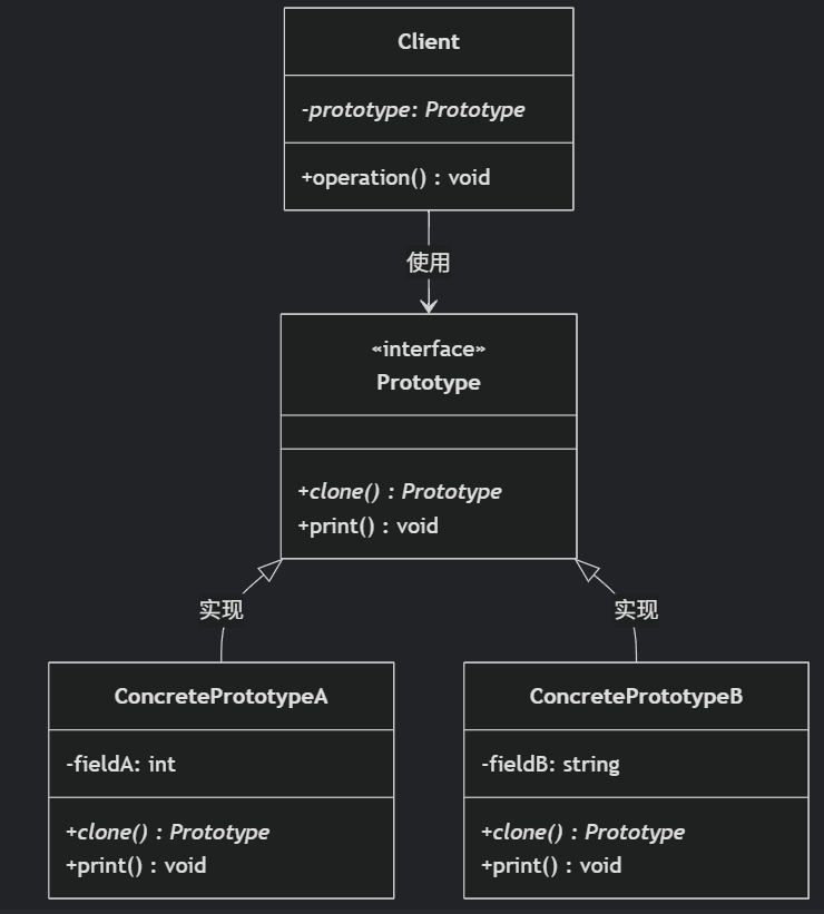
(二)原型模式
原型的功能是将一个已经存在的对象作为源目标,其余对象都是通过这个源目标创建。发挥复制的作用就是原型模式的核心思想。 一、源型模式的定义 原型模式是指第二次创建对象可以通过复制已经存在的原型对象来实现,忽略对象创建过程中的其它细节。 📌 核心特点: 避免重复初…...

基于Docker Compose部署Java微服务项目
一. 创建根项目 根项目(父项目)主要用于依赖管理 一些需要注意的点: 打包方式需要为 pom<modules>里需要注册子模块不要引入maven的打包插件,否则打包时会出问题 <?xml version"1.0" encoding"UTF-8…...
)
GitHub 趋势日报 (2025年06月08日)
📊 由 TrendForge 系统生成 | 🌐 https://trendforge.devlive.org/ 🌐 本日报中的项目描述已自动翻译为中文 📈 今日获星趋势图 今日获星趋势图 884 cognee 566 dify 414 HumanSystemOptimization 414 omni-tools 321 note-gen …...

力扣-35.搜索插入位置
题目描述 给定一个排序数组和一个目标值,在数组中找到目标值,并返回其索引。如果目标值不存在于数组中,返回它将会被按顺序插入的位置。 请必须使用时间复杂度为 O(log n) 的算法。 class Solution {public int searchInsert(int[] nums, …...

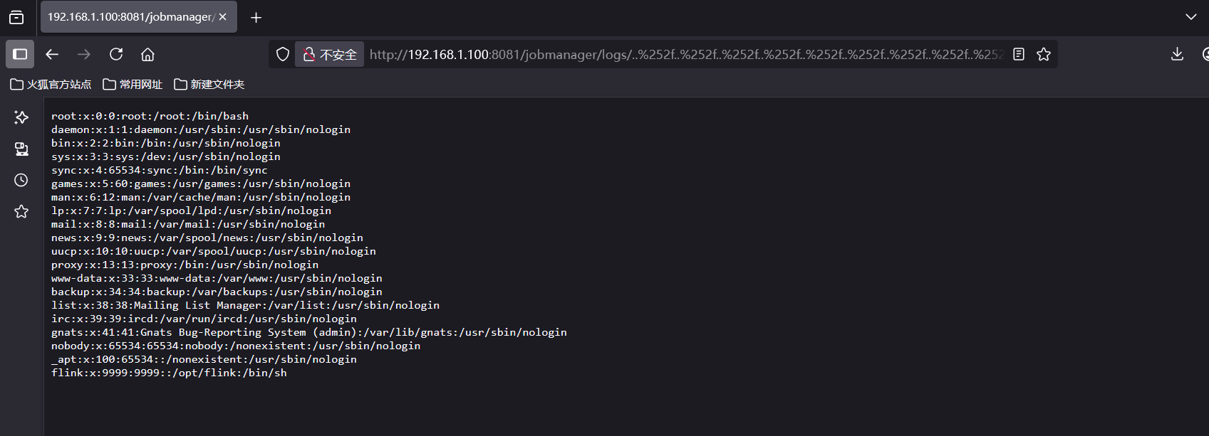
CVE-2020-17519源码分析与漏洞复现(Flink 任意文件读取)
漏洞概览 漏洞名称:Apache Flink REST API 任意文件读取漏洞CVE编号:CVE-2020-17519CVSS评分:7.5影响版本:Apache Flink 1.11.0、1.11.1、1.11.2修复版本:≥ 1.11.3 或 ≥ 1.12.0漏洞类型:路径遍历&#x…...

GitFlow 工作模式(详解)
今天再学项目的过程中遇到使用gitflow模式管理代码,因此进行学习并且发布关于gitflow的一些思考 Git与GitFlow模式 我们在写代码的时候通常会进行网上保存,无论是github还是gittee,都是一种基于git去保存代码的形式,这样保存代码…...
详细解析)
Caliper 负载(Workload)详细解析
Caliper 负载(Workload)详细解析 负载(Workload)是 Caliper 性能测试的核心部分,它定义了测试期间要执行的具体合约调用行为和交易模式。下面我将全面深入地讲解负载的各个方面。 一、负载模块基本结构 一个典型的负载模块(如 workload.js)包含以下基本结构: use strict;/…...

Python环境安装与虚拟环境配置详解
本文档旨在为Python开发者提供一站式的环境安装与虚拟环境配置指南,适用于Windows、macOS和Linux系统。无论你是初学者还是有经验的开发者,都能在此找到适合自己的环境搭建方法和常见问题的解决方案。 快速开始 一分钟快速安装与虚拟环境配置 # macOS/…...

表单设计器拖拽对象时添加属性
背景:因为项目需要。自写设计器。遇到的坑在此记录 使用的拖拽组件时vuedraggable。下面放上局部示例截图。 坑1。draggable标签在拖拽时可以获取到被拖拽的对象属性定义 要使用 :clone, 而不是clone。我想应该是因为draggable标签比较特。另外在使用**:clone时要将…...

