Global Mapper SDK 19 中文开发文档(八)
7.2.8 GM_DBUtil
(1)声明
public static class GM_DBUtil(2)方法
| 方法 | 描述 |
| DBGetTableList | 获取指定空间数据库中的表列表 |
| DBIsDatabaseFile | 指示输入文件是否为数据库(Esri地理数据库、Spatialite等) |
| DBMakeConnectionString | 从输入连接参数创建连接字符串 |
| DBSelectExportTable | 显示对话框,允许用户选择要导出数据的表 |
| DBSelectTable | 显示对话框,允许用户选择一个或多个要加载的表 |
| DBTableList_Free | 释放与表列表关联的内存 |
| DBTableList_GetCount | 获取表列表中的表数 |
| DBTableList_GetTableName | 获取指定索引处的表名 |
| DBTestConnection | 测试输入的连接字符串,以查看是否可以用于连接到数据库 |
DBGetTableList
public static GM_Error_t32 DBGetTableList(out IntPtr aTableList,    //Table list handlestring aConnectionInfo    //Connection string or database file name
)
DBIsDatabaseFile
public static bool DBIsDatabaseFile(string aFileName    //The file name
)
DBMakeConnectionString
public static GM_Error_t32 DBMakeConnectionString(out string aConnectionStr,                //The connection string bufferuint aBufferLength,                       //The length of the connection string bufferGM_DBConnectionParams_t aConnectionParams //The connection parameters
)
DBSelectExportTable
public static GM_Error_t32 DBSelectExportTable(out string aTable,        //Buffer for storing table nameuint aBufferLength,       //The length of the table name bufferout bool aTableExists,    //Indicates whether or not the selected table existsstring aConnectionStr     //Connection parameter string or database file name
)
DBSelectTable
public static GM_Error_t32 DBSelectTable(out IntPtr aTableList,    //Handle for list of selected table namesstring aConnectionStr     //Connection parameter string or database file name
)
DBTableList_Free
public static GM_Error_t32 DBTableList_Free(ref IntPtr aTableList    //Table list handle to be freed
)
DBTableList_GetCount
public static GM_Error_t32 DBTableList_GetCount(out uint aCount,    //The number of table names in the listIntPtr aTableList   //Table list handle
)
DBTableList_GetTableName
public static GM_Error_t32 DBTableList_GetTableName(out string aTableName,    //Buffer in which table name will be placeduint aIndex,              //The zero-based index for the table nameIntPtr aTableList         //Table list handle
)
DBTestConnection
public static GM_Error_t32 DBTestConnection(string aConnectionStr    //Connection parameter string
)
7.2.9 GM_Exception
(1)声明
public class GM_Exception : Exception(2)构造函数
public GM_Exception()public GM_Exception(string message    //Any additional error information that could be gathered
)public GM_Exception(GM_Error_t32 error    //The GM_Error to be assosicated with this exception
)public GM_Exception(string message,    //Any additional error information that could be gatheredException inner    //The Inner Exception
)public GM_Exception(GM_Error_t32 error,    //The GM_Error to be assosicated with this exceptionstring message         //Any additional error information that could be gathered
)
(3)属性
| 属性 | 描述 |
| ErrorCode | 与异常相关的GM_Error Code |
ErrorCode
public GM_Error_t32 ErrorCode { get; }7.2.10 GM_Export
(1)声明
public static class GM_Export(2)方法
| 方法 | 描述 |
| ExportElevation | 将一个或多个图层导出为新的分块高程文件。 |
| ExportElevationEx | 将一个或多个图层导出为新的分块高程文件。 |
| ExportMapLayoutComponent | 将地图布局组件导出为位图图像文件。 |
| ExportPackage | 将一个或多个图层导出为新的包文件(在WinCE上未实现)。 |
| ExportPDF | 将一个或多个图层导出为新的GeoPDF文件(在WinCE上未实现)。 |
| ExportRaster | 将一个或多个图层导出为新的栅格文件(在WinCE上未实现)。 |
| ExportRasterEx | 将一个或多个图层导出为新的栅格文件(在WinCE上未实现)。 |
| ExportRasterFromBitmap | 将一个或多个图层导出为新的栅格文件(在WinCE上未实现)。 |
| ExportVector | 将一个或多个图层导出为新的矢量文件(在WinCE上未实现)。 |
| ExportVectorList | 将一个或多个图层导出为新的矢量文件(在WinCE上未实现)。 |
| ExportWebFormat | 将一个或多个图层导出为适用于在Web浏览器或其他基于Web的工具中显示的Web格式文件。 |
| SetExportCropAreas | 在导出时设置要使用的裁剪区域。 |
7.2.11 GM_ExportOptsPDF_t
(1)声明
public class GM_ExportOptsPDF_t(2)构造函数
public GM_ExportOptsPDF_t()(3)字段
| 方法 | 描述 |
| mBorderColor | 边框线颜色。 |
| mBorderStyle | 边框线样式(如实线、虚线等)。 |
| mBorderWidth | 边框线宽度(以PDF点为单位的像素)。 |
| mDPI | 导出DPI。 |
| mFlags | 导出标志。 |
| mFooterFont | 页脚字体(默认为NULL)。 |
| mFooterStr | 页面页脚(无页脚则为NULL)。 |
| mHeaderFont | 页眉字体(默认为NULL)。 |
| mHeaderStr | 页面页眉(无页眉则为NULL)。 |
| mMarginRect | 边距(以英寸为单位)。 |
| mPageSizeName | 页面大小名称,如“Letter”,“Legal”,“A0”等。 |
| mSymbolScale | 点符号缩放因子(0.0将被视为1.0,使用2.0可以将大小加倍,0.5可以减半等)。 |
7.2.12 GM_FindFeatures
(1)声明
public static class GM_FindFeatures(2)方法
| 方法 | 描述 |
| FindFeaturesInArea | 查找包含在给定区域要素内的要素。 |
| FindNearestAddress | 查找离搜索位置最近的地址。 |
| FindNearestFeatures | 查找与给定像素位置的像素距离内的要素。 |
FindFeaturesInArea
public static GM_Error_t32 FindFeaturesInArea(GM_LayerList_t aLayerList,                //List of layers to search or NULL for all vector layersGM_FindFlags_t32 aFindFlags,              //Flags controlling how the find is performedGM_AreaFeature_t aAreaToSearch,           //Area feature to search (use GM_GetAreaFeature to get from loaded layer)GM_Projection_t aAreaProj,                //Projection of coordinates in area feature (use GM_GetLayerInfo()->mNativeProj to get layer projection)
aResultsout GM_FoundFeatureResults_t aResults,    //Results of find operation (use GM_FreeFeatureResultList to free when done)Object aReserved                          //Reserved for later use, must be NULL (0)
)
FindNearestAddress
public static GM_Error_t32 FindNearestAddress(GM_Point_t aSearchPt,        //Search location in current view projection (as returned by GM_SetProjection)GM_LayerList_t aLayerList,   //List of layers to search or NULL for all vector layersout string aAddressStr,      //Buffer to hold string for nearest addressuint aMaxAddressLen,         //Maximum length of string to store in outputdouble aMaxDistMeters,       //Maximum distance in meters to search around search pointObject aReserved             //Reserved for later use, must be NULL (0)
)
FindNearestFeatures
public static GM_Error_t32 FindNearestFeatures(GM_Point_t aPixelSearchPt,                        //Search location in pixel coordinatesGM_LayerList_t aLayerList,                        //List of layers to search or NULL for all vector layersGM_FindFlags_t32 aFindFlags,                      //Flags controlling how the find is performedGM_Rectangle_t aWorldBounds,                      //World bounds for search space or NULL for last drawnGM_PixelRect_t aPixelRect,                        //Pixel bounds for search space or NULL for last drawnout GM_FoundFeatureCollection_t aNearestFeatures, //List of nearest features (buffer for GM_FoundFeature_t)uint aMaxFeatures,                                //Max number of nearest features to finduint aMaxDistPixels                               //Max distance in pixels to search
)
7.2.13 GM_FontDef_t
(1)声明
public class GM_FontDef_t(2)构造函数
public GM_FontDef_t()(3)方法
| 方法 | 描述 |
| ToString() | 返回对象的字符串表示形式 (覆盖了Object.ToString()方法)。 |
| ToString(String) | 返回对象的字符串表示形式。 |
ToString
public override string ToString()public string ToString(string theOptions    //Additional Font Info: (A) for all, (C) for Color, (F) for Format, (O) for Other
)
(4)操作符
| 操作符 | 描述 |
| Equality | 根据句柄比较两个图层的相等性。 |
| Inequality | 根据句柄比较两个图层的不相等性。 |
Equality
public static bool operator ==(GM_FontDef_t left,    //The Left LayerGM_FontDef_t right    //The Right Layer
)
Inequality
public static bool operator !=(GM_FontDef_t left,    //The Left LayerGM_FontDef_t right    //The Right Layer
)
(5)字段
| 字段 | 描述 |
| mAngle | 逆时针旋转角度(0表示从左到右水平)。 |
| mBgMode | 背景填充模式(不透明或透明)。 |
| mCharset | 字符集(使用OEM_CHARSET(255)获取默认行为)。 |
| mColor | 字体的RGB颜色。 |
| mFaceName | 使用的字体名称。 |
| mFixedHgt | 字体的固定高度(以米为单位)(使用0.0表示正常字号字体)。 |
| mHalo | 围绕文本绘制细边框,以在任何背景上使其可见。 |
| mItalicize | 使用斜体绘制文本。 |
| mPlacement | 标签相对于点要素的放置方式(仅适用于点要素)。 |
| mPointSize | 字体的字号(将mFixedHgt值设置为非零以使用固定高度)。 |
| mReserved2 | 保留,必须为0。 |
| mReserved3 | 保留,必须为0。 |
| mStrikeout | 删除线文本。 |
| mUnderline | 下划线文本。 |
| mWeight | 字体的粗细(使用GM_Constants,如FW_BOLD,FW_THIN,FW_NORMAL等)。 |
7.2.14 GM_FoundFeature_t
(1)声明
public class GM_FoundFeature_t(2)属性
| 属性 | 描述 |
| mDistance | 距离搜索位置的特征像素距离(只读)。 |
| mFeatureClassType | 要素类别(区域、点、线)(只读)。 |
| mFeatureIndex | 要素在图层中的索引(只读)。 |
| mLayer | 要素所在的图层(只读)。 |
mDistance
public uint mDistance { get; }mFeatureClassType
public GM_FeatureClassType_t8 mFeatureClassType { get; }mFeatureIndex
public uint mFeatureIndex { get; }mLayer
public GM_Layer_t mLayer { get; }(3)方法
| 方法 | 描述 |
| CompareLayer | 将此找到的图层与给定的图层进行比较。 |
CompareLayer
public bool CompareLayer(GM_Layer_t aLayer    //The layer to compare against
)
(4)操作符
| 操作符 | 描述 |
| Equality | 检查两个找到的要素之间是否相等。 |
| Inequality | 检查两个找到的要素之间是否不相等。 |
Equality
public static bool operator ==(GM_FoundFeature_t left,    //Left side feature to compareGM_FoundFeature_t right    //Right side feature to compare
)
Inequality
public static bool operator !=(GM_FoundFeature_t left,    //Left side feature to compareGM_FoundFeature_t right    //Right side feature to compare
)
7.2.15 GM_FoundFeatureCollection_t
(1)声明
public class GM_FoundFeatureCollection_t(2)属性
| 属性 | 描述 |
| Count | 找到的要素数量。 |
| Item | 找到的要素列表。 |
Count
public int Count { get; }Item
public GM_FoundFeature_t this[int index
] { get; }
(3)方法
| 方法 | 描述 |
| GetAreas | 从 FoundFeatureCollection 中获取所有区域要素的列表。 |
| GetLidarPoints | 从 FoundFeatureCollection 中获取所有激光雷达点要素的列表。 |
| GetLines | 从 FoundFeatureCollection 中获取所有线要素的列表。 |
| GetPoints | 从 FoundFeatureCollection 中获取所有点要素的列表。 |
GetAreas
public GM_AreaFeature_t[] GetAreas(GM_GetFeatureFlags_t32 aFlags = 0    //Flags for the get area feature operation
)
GetLidarPoints
public GM_LidarPoint_t[] GetLidarPoints(GM_GetFeatureFlags_t32 aFlags = 0    //Flags for the get point feature operation
)
GetLines
public GM_LineFeature_t[] GetLines(GM_GetFeatureFlags_t32 aFlags = 0    //Flags for the get line feature operation
)
GetPoints
public GM_PointFeature_t[] GetPoints(GM_GetFeatureFlags_t32 aFlags = 0    //Flags for the get point feature operation
)
7.2.16 GM_FoundFeatureResults_t
(1)声明
public class GM_FoundFeatureResults_t : IDisposable(2)属性
| 属性 | 描述 |
| mFeatureCount | 结果列表中的要素数量。 |
mFeatureCount
public ulong mFeatureCount { get; }(3)方法
| 方法 | 描述 |
| Dispose | 释放非托管资源。 |
Dispose
public void Dispose()(4)字段
| 字段 | 描述 |
| mFeatureList | 找到的要素列表。 |
7.2.17 GM_GPSUtil
(1)声明
public static class GM_GPSUtil(2)方法
| 方法 | 描述 |
| GPSGetAltitude | 获取当前的GPS海拔高度,如果有效。 |
| GPSGetBearing | 获取当前的GPS方位角,如果有效。 |
| GPSGetFixInfo | 获取当前的GPS定位准确性统计信息。 |
| GPSGetFixType | 获取当前的GPS定位类型。 |
| GPSGetLocation | 获取当前的GPS位置。 |
| GPSGetTime | 以C风格的时间加小数秒的形式获取最后一次GPS定位的UTC时间。 |
| GPSGetVelocity | 获取当前的GPS速度,如果有效。 |
| GPSRenderVessel | 在当前GPS位置将给定大小的GPS船舶渲染到提供的设备上下文中。 |
| GPSStartTrackingNMEAFile | 回放从NMEA日志文件中记录的GPS轨迹。 |
| GPSStartTrackingSerial | 开始跟踪连接到串行端口的GPS设备。 |
| GPSStartTrackingUSB | 开始跟踪连接到USB端口的GPS设备。 |
| GPSStopTracking | 停止跟踪任何已连接的GPS设备。 |
GPSGetAltitude
public static GM_Error_t32 GPSGetAltitude(out float aAltitude    //current GPS altitude in meters
)
GPSGetBearing
public static GM_Error_t32 GPSGetBearing(out float aBearing    //current GPS bearing in radians from due north
)
GPSGetFixInfo
public static GM_Error_t32 GPSGetFixInfo(out float aHorzPosError,    //current horizontal position error in meters (0.0 if unknown)out float aVertPosError,    //current vertical position error in meters (0.0 if unknown)out float aPDOP,            //current position DOP in meters (0.0 if unknown)out uint aNumSats           //number of satellites used in fix (0 if unknown)
)
GPSGetFixType
public static GM_gps_fix_t8 GPSGetFixType()GPSGetLocation
public static GM_Error_t32 GPSGetLocation(out GM_Point_t aCurPos,    //current GPS locationbool aGetLatLon            //retrieve coordinates in lat/lon/WGS84 rather than global coords
)
GPSGetTime
public static GM_Error_t32 GPSGetTime(out DateTime aFixTime    //fix time
)
GPSGetVelocity
public static GM_Error_t32 GPSGetVelocity(out float aVelocity    //current GPS velocity in m/s
)
GPSRenderVessel
public static GM_Error_t32 GPSRenderVessel(IntPtr aDC,                    //(HDC) Device context to draw toGM_Rectangle_t aWorldBounds,   //World bounds to convert from or NULL for last drawnGM_PixelRect_t aPixelRect,     //Pixel bounds to convert from or NULL for last drawn uint aVesselHeight,            //The vessel height in pixelsuint aVesselWidth,             //The vessel width in pixelsuint aVesselColor              //The color to render the vessel in
)
GPSStartTrackingNMEAFile
public static GM_Error_t32 GPSStartTrackingNMEAFile(string aFilename,                    //full path to NMEA file to useGM_gps_nmea_flags_t32 aNmeaFlags,    //flags controlling NMEA playbackGM_GPSCallbackFunc aCallbackFunc,    //optional callback functionObject aReserved                     //reserved value (must be NULL)
)
GPSStartTrackingSerial
public static GM_Error_t32 GPSStartTrackingSerial(GM_gps_format_t8 aFormat,            //format (NMEA or Garmin)byte aPort,                          //COM port for serial connectionsuint aBaud,                          //baud rate for serial portGM_GPSCallbackFunc aCallbackFunc,    //optional callback functionuint aReserved                       //32-bit reserved value (must be 0)
)
GPSStartTrackingUSB
public static GM_Error_t32 GPSStartTrackingUSB(GM_GPSCallbackFunc aCallbackFunc,     //optional callback functionuint aReserved                        //32-bit reserved value (must be 0)
)
GPSStopTracking
public static GM_Error_t32 GPSStopTracking()7.2.18 GM_GridGenSetup_t
(1)声明
public class GM_GridGenSetup_t(2)构造函数
public GM_GridGenSetup_t()(3)字段
| 字段 | 描述 |
| mBounds | (GM_Rectangle_t *)要将边界框网格化到当前的投影单位中。如果要使用所有输入图层的合并边界,则传递NULL(默认值)。 |
| mDesc | 网格描述 |
| mElevUnits | 在哪些单位上生成网格(如果需要,将转换其他单位的高程值) |
| mFlags | 网格生成的标志 |
| mGridAlg | 用于创建高程网格的算法(如果有) |
| mGridBinMult | 如果使用基于 bin 的网格方法,则使用网格 bin 倍数。这是计算点密度的倍数。 |
| mLidarBreaklineBinMult | 在应用断线高度和填充间隙之前,从Lidar网格周围清除的单元格数目(如果使用GM_GridGen_ApplyLidarBreaklines有效)。通常在1-4范围内。 |
| mTaperValue | 区域网格化的锥度值。 0.0表示无锥度(默认值) |
| mTightnessMult | 网格紧密度乘数(乘以分辨率),以丢弃远离样本的值。默认值为零,不会丢弃任何值。对于Lidar bin网格化,通常不希望使用0,因为它可能会非常缓慢,以填充不规则的Lidar数据中的所有间隙。使用GM_GRID_DISABLE_GAP_FILL完全禁用填充间隙。对于Lidar bin网格,间隙填充值通常在1-32范围内。 |
| mXRes | 在当前的投影单位中生成网格的X分辨率(使用0.0进行自动间隔确定) |
| mYRes | 在当前的投影单位中生成网格的Y分辨率(使用0.0进行自动间隔确定) |
7.2.19 GM_Layer_t
(1)声明
public class GM_Layer_t : IDisposable(2)构造函数
public GM_Layer_t(string aFilename,                //The Path to the file to be loadedGM_LoadFlags_t32 aLoadFlags = 0  //Flags for load options
)
(3)属性
| 属性 | 描述 |
| Closed | 返回图层的关闭状态。 |
Closed
public bool Closed { get; }(4)方法
| 方法 | 描述 |
| AddAreaToVectorLayer | 向加载的矢量图层添加区域要素 |
| AddLineToVectorLayer | 向加载的矢量图层添加点要素 |
| AddPointToVectorLayer | 向加载的矢量图层添加点要素 |
| Close | 关闭图层并清理非托管代码。返回GM_Error_t32 |
| CombineTerrainLayers | 通过组合两个加载的地形网格图层创建一个新的地形图层(在WinCE上未实现) |
| CreateCustomElevGridLayer | 创建一个用于内存高程网格的新的自定义图层(在WinCE上未实现) |
| CreateCustomRasterLayer | 创建一个用于内存栅格网格的新的自定义图层(在WinCE上未实现) |
| CreateCustomVectorLayer | 创建一个用于添加矢量要素的新的自定义图层 |
| CreateVectorLayerFromFindResults | 根据查找操作的结果创建一个新的矢量图层 |
| Dispose | 与Close执行相同的操作 |
| Draw | 将指定图层的指定部分绘制到DIB中。如果没有显式指定图层,则将绘制所有加载的图层。 |
| Equals | 根据句柄比较两个图层的相等性(重写Object.Equals(Object)。) |
| FlushCache | 刷新图层的任何内存缓存(在低内存环境中非常有用) |
| GetAreaFeature | 获取指定索引处具有可选标志的该图层中的区域要素。 |
| GetAreaFeatureEx | 获取指定索引处具有可选标志的该图层中的区域要素。 |
| GetAvailableOnlineSourceList | 检索所有可用的在线源的列表 |
| GetFeatureElevation | 获取要素的高程。使用SetLayerElevationAttribute设置高程属性的名称。 |
| GetLayerInfo | 返回有关指定图层的信息的副本。如果图层未加载,则返回NULL。 |
| GetLayerLidarStats | 从Lidar图层检索统计数据 |
| GetLidarPoint | 从图层中检索给定索引处的Lidar点要素 |
| GetLineFeature | 以可选标志获取该图层中指定索引处的线要素 |
| GetLineFeatureEx | 以可选标志获取该图层中指定索引处的线要素 |
| GetLocationColor(Double, Double, GM_Color_t) | 从提供的图层或当前加载的栅格和高程图层列表(最顶层图层优先)中的给定位置检索颜色 |
| GetLocationColor(GM_Layer_t, Double, Double, GM_Color_t) | 从提供的图层或当前加载的栅格和高程图层列表(最顶层图层优先)中的给定位置检索颜色 |
| GetLocationElevation(Double, Double, Single) | 从提供的图层或当前加载的高程图层列表(最顶层高程图层优先)中的给定位置检索高程 |
| GetLocationElevation(GM_Layer_t, Double, Double, Single) | 从提供的图层或当前加载的高程图层列表(最顶层高程图层优先)中的给定位置检索高程 |
| GetOnlineSourceInfo | 获取有关在线源的详细信息并检查可用性 |
| GetPixelBandValue(Int32, Int32, Int32, Int32) | 从提供的图层中检索给定像素位置的波段值 |
| GetPixelBandValue(GM_Layer_t, Int32, Int32, Int32, Int32) | 从提供的图层中检索给定像素位置的波段值 |
| GetPixelColor(Int32, Int32, GM_Color_t) | 从提供的图层中检索给定像素位置的颜色 |
| GetPixelColor(GM_Layer_t, Int32, Int32, GM_Color_t) | 从提供的图层中检索给定像素位置的颜色 |
| GetPixelColorRow(Int32,Color[], Color) | 从提供的图层中检索整行颜色值 |
| GetPixelColorRow(GM_Layer_t, Int32,Color[], Color) | 从提供的图层中检索整行颜色值 |
| GetPixelElevation(Int32, Int32, Single) | 从提供的图层中检索给定像素位置的高程 |
| GetPixelElevation(GM_Layer_t, Int32, Int32, Single) | 从提供的图层中检索给定像素位置的高程 |
| GetPixelElevationRow(Int32,Single[], Single) | 从提供的图层中检索整行高程值 |
| GetPixelElevationRow(GM_Layer_t, Int32,Single[], Single) | 从提供的图层中检索整行高程值 |
| GetPointFeature | 使用可选标志获取该图层中指定索引处的点要素的副本 |
| GetPointFeatureEx | 使用可选标志获取该图层中指定索引处的点要素的副本 |
| IsFeatureDeleted | 查询图层中给定索引处要素的删除状态 |
| LoadGenericAsciiTextLayer | 从简单的ASCII文本文件中加载新的图层。将指向该图层的指针存储以便后续调用使用。 |
| LoadLayer | 加载数据文件(已弃用) |
| LoadOnlineLayer | 从在线源(如WMS服务器或TerraServer-USA)加载数据 |
| LoadRectifiedLayer | 从文件中加载新的图层。将指向该图层的指针存储以便后续调用使用。该图层将使用提供的地面控制点和投影进行校正。 |
| RepositionLayer | 重新定位/重投影先前加载的栅格图层 |
| SetAreaFeatureClass | 设置给定要素使用的分类。 |
| SetAreaFeatureDrawStyle | 设置用于区域要素的绘制样式 |
| SetAreaFeaturePointList | 设置用于给定区域要素的点位置列表 |
| SetAreaFeaturePointListEx | 设置用于给定区域要素的点位置列表,包括每个顶点的高程。 |
| SetCodePage | 设置图层的代码页解释 |
| SetFeatureAttrList | 设置用于指定要素的属性值列表。 |
| SetFeatureDelete | 更改图层中给定索引处要素的删除状态 |
| SetFeatureDescription | 设置要素使用的描述。 |
| SetFeatureLabel | 设置要素使用的显示标签。 |
| SetLayerDescription | 设置图层的描述 |
| SetLayerElevationAttribute | 设置用于检索该图层内要素的高程值的属性名称。 |
| SetLayerElevationUnits | 设置用于没有高程单位的3D矢量要素的高程单位 |
| SetLayerEnabled | 设置给定图层是否启用显示。如果禁用,该图层将永远不会被绘制,也不会用作其他半透明或贴图图层的输入。 |
| SetLayerHeightAttribute | 设置用于从该图层内获取点要素的高度值的属性名称。 |
| SetLayerHeightUnits | 设置用于没有高度单位的3D矢量要素的高度单位 |
| SetLayerLabelAttribute | 设置用于设置该图层内要素显示标签的属性名称。 |
| SetLayerPalette | 为图层设置自定义调色板,以覆盖现有调色板。仅适用于基于调色板的图层。 |
| SetLayerUserData | 为图层设置用户数据。 |
| SetLayerUserText | 为图层设置用户文本。保存到工作空间后仍保持不变。 |
| SetLidarPoint | 设置给定索引处从该图层中获取的Lidar点要素 |
| SetLineFeatureClass | 设置给定要素使用的分类。 |
| SetLineFeatureDrawStyle | 设置用于线要素的绘制样式 |
| SetLineFeaturePointList | 设置用于给定线要素的点位置列表 |
| SetLineFeaturePointListEx | 设置用于给定线要素的点位置列表,包括高程列表。 |
| SetPointFeatureClass | 设置给定要素使用的分类。 |
| SetPointFeatureDrawStyle | 设置用于点要素的绘制样式 |
| SetPointFeaturePosition | 设置用于给定点要素的位置 |
| ShowOptionsDialog | 显示图层的显示选项对话框 |
| ToString | 返回对象的字符串表示形式(重写Object.ToString()方法) |
AddAreaToVectorLayer
public GM_Error_t32 AddAreaToVectorLayer(GM_AreaFeature_t aArea,         //Area feature to addGM_AddFeatureFlags_t8 aFlags    //Flags controlling the add
)
AddLineToVectorLayer
public GM_Error_t32 AddLineToVectorLayer(GM_LineFeature_t aLine,        //Line feature to addGM_AddFeatureFlags_t8 aFlags   //Flags controlling the add
)
AddPointToVectorLayer
public GM_Error_t32 AddPointToVectorLayer(GM_PointFeature_t aPoint,    //Point feature to addGM_AddFeatureFlags_t8 aFlags //Flags controlling the add
)
Close
public GM_Error_t32 Close()CombineTerrainLayers
public static GM_Layer_t CombineTerrainLayers(GM_GridCombineSetup_t aSetup,    //Setup for operationObject aReserved                 //Reserved for future use, must be NULL
)
CreateCustomElevGridLayer
public static GM_Layer_t CreateCustomElevGridLayer(string aDescription,            //Description to use for layer (can be NULL to use default)GM_Projection_t aProj,          //Native projection of new layerGM_GridLayout_t aGridLayout,    //Grid layer layout and typeIntPtr aElevGrid,               //Grid of elevation values in row-major orderObject aReserved                //Reserved for future use (must be NULL)
)
CreateCustomRasterLayer
public static GM_Layer_t CreateCustomRasterLayer(string aDescription,                //Description to use for layer (can be NULL to use default)GM_Projection_t aProj,              //Native projection of new layerGM_RasterLayout_t aRasterLayout,    //Raster layer layoutIntPtr aDataBuf                     //Grid of raster data values in row-major order
)
CreateCustomVectorLayer
public static GM_Layer_t CreateCustomVectorLayer(string aDescription,    //Description to use for layer (can be NULL to use default)GM_Projection_t aProj   //Native projection of new layer
)
CreateVectorLayerFromFindResults
public static GM_Layer_t CreateVectorLayerFromFindResults(string aDescription,                    //Description to use for layer (can be NULL to use default)GM_Projection_t aProj,                  //Native projection of new layerGM_FoundFeatureResults_t aResultList    //Results of find operation to create layer from
)
Dispose
public void Dispose()Draw
public GM_Error_t32 Draw(IntPtr aDC,                    //Device context to draw toGM_Rectangle_t aWorldBounds,   //World bounds to draw or NULL for allint aLeftPixel,                //Left pixel coordinate to draw toint aTopPixel,                 //Top pixel coordinate to draw toint aPixelWidth,               //Width in pixels to drawint aPixelHeight               //Height in pixels to draw
)
Equals
public override bool Equals(Object obj    //The layer to compare to this one
)
FlushCache
public GM_Error_t32 FlushCache()GetAreaFeature
public GM_AreaFeature_t GetAreaFeature(uint aIndex    //Index of Area feature to retrieve
)
GetAreaFeatureEx
public GM_AreaFeature_t GetAreaFeatureEx(uint aIndex,                    //Index of Area feature to retrieveGM_GetFeatureFlags_t32 aFlags,  //Flags for fetching featureObject aReserved                //Reserved for future use, must be NULL
)
GetAvailableOnlineSourceList
public static GM_OnlineSourceInfo_t[] GetAvailableOnlineSourceList()GetFeatureElevation
public GM_Error_t32 GetFeatureElevation(GM_FeatureClassType_t8 aFeatureClassType,    //Type of feature class (area, point, line)uint aFeatureIndex,                          //Index of feature in layerout float aElev                              //Elevation of feature (in meters)
)
GetLayerInfo
public GM_LayerInfo_t GetLayerInfo()GetLayerLidarStats
public GM_Error_t32 GetLayerLidarStats(out GM_LidarStats_t aLidarStats,    //Buffer to hold stats inObject aReserved                    //Reserved for future use, must be NULL
)
GetLidarPoint
public GM_Error_t32 GetLidarPoint(ulong aPointIndex,                //Index of Lidar point feature to retrieveout GM_LidarPoint_t aLidarPoint,  //Lidar point to fill inGM_GetFeatureFlags_t32 aFlags,    //Flags for fetching Lidar pointObject aReserved                  //Reserved for future use, must be NULL
)
GetLineFeature
public GM_LineFeature_t GetLineFeature(uint aIndex    //Index of Line feature to retrieve
)
GetLineFeatureEx
public GM_LineFeature_t GetLineFeatureEx(uint aIndex,                    //Index of Line feature to retrieveGM_GetFeatureFlags_t32 aFlags,  //Flags for fetching featureObject aReserved                //Reserved for future use, must be NULL
)
GetLocationColor
public GM_Error_t32 GetLocationColor(double aXCoord,        //X coord in current projectiondouble aYCoord,        //Y coord in current projectionout GM_Color_t aColor  //Color of pixel at location
)public static GM_Error_t32 GetLocationColor(GM_Layer_t aLayer,     //Layer to get color from or NULL for topmostdouble aXCoord,        //X coord in current projectiondouble aYCoord,        //Y coord in current projectionout GM_Color_t aColor  //Color of pixel at location
)
GetLocationElevation
public GM_Error_t32 GetLocationElevation(double aXCoord,    //X coord in current projectiondouble aYCoord,    //Y coord in current projectionout float aElev    //Elevation at location in meters
)public static GM_Error_t32 GetLocationElevation(GM_Layer_t aLayer,    //Layer to get elevation from or NULL for topmostdouble aXCoord,       //X coord in current projectiondouble aYCoord,       //Y coord in current projectionout float aElev       //Elevation at location in meters
)
GetOnlineSourceInfo
public static GM_Error_t32 GetOnlineSourceInfo(string aSourceName,                      //Name of online source to get detail info forout GM_OnlineSourceInfo_t aSourceInfo,   //Detailed information about provided source, mostly in attributesObject aReserved                         //Reserved for future use, must be NULL
)
GetPixelBandValue
public GM_Error_t32 GetPixelBandValue(int aRow,        //Y coord of pixel (0 is topmost)int aCol,        //X coord of pixel (0 is leftmost)int aBand,       //Band to get value for (0-based, so first band is 1)out int aVal     //Color of pixel at location
)public static GM_Error_t32 GetPixelBandValue(GM_Layer_t aLayer,    //Layer to get color fromint aRow,             // Y coord of pixel (0 is topmost)int aCol,             //X coord of pixel (0 is leftmost)int aBand,            //Band to get value for (0-based, so first band is 1)out int aVal          //Color of pixel at location
)
GetPixelColor
public GM_Error_t32 GetPixelColor(int aRow,                //Y coord of pixel (0 is topmost)int aCol,                //X coord of pixel (0 is leftmost)out GM_Color_t aColor    //Color of pixel at location
)public static GM_Error_t32 GetPixelColor(GM_Layer_t aLayer,        //Layer to get color fromint aRow,                 //Y coord of pixel (0 is topmost)int aCol,                 //X coord of pixel (0 is leftmost)out GM_Color_t aColor     //Color of pixel at location
)
GetPixelColorRow
public GM_Error_t32 GetPixelColorRow(int aRow,                //Y coord of pixel (0 is topmost)out Color[] aColorRow,   //Pointer to arrow to hold color values for rowColor aInvalidVal        //Value to use for invalid pixels
)public static GM_Error_t32 GetPixelColorRow(GM_Layer_t aLayer,        //Layer to get color fromint aRow,                 //Y coord of pixel (0 is topmost)out Color[] aColorRow,    //Pointer to arrow to hold color values for rowColor aInvalidVal         //Value to use for invalid pixels
)
GetPixelElevation
public GM_Error_t32 GetPixelElevation(int aRow,        //Y coord of pixel (0 is topmost)int aCol,        //X coord of pixel (0 is leftmost)out float aElev  //Elevation at location in meters
)public static GM_Error_t32 GetPixelElevation(GM_Layer_t aLayer,    //Layer to get elevation fromint aRow,             //Y coord of pixel (0 is topmost)int aCol,             //X coord of pixel (0 is leftmost)out float aElev       //Elevation at location in meters
)
GetPixelElevationRow
public GM_Error_t32 GetPixelElevationRow(int aRow,                //Y coord of pixel (0 is topmost)out float[] aElevRow,    //Buffer to hold elevation values for row in metersfloat aInvalidVal        //Value to use for invalid samples (i.e. -9999.9)
)public static GM_Error_t32 GetPixelElevationRow(GM_Layer_t aLayer,        //Layer to get elevation fromint aRow,                 //Y coord of pixel (0 is topmost)out float[] aElevRow,     //Buffer to hold elevation values for row in metersfloat aInvalidVal         //Value to use for invalid samples (i.e. -9999.9)
)
GetPointFeature
public GM_PointFeature_t GetPointFeature(uint aIndex    //Index of Point feature to retrieve
)
GetPointFeatureEx
public GM_PointFeature_t GetPointFeatureEx(uint aIndex,                    //Index of Point feature to retrieveGM_GetFeatureFlags_t32 aFlags,  //Flags for fetching featureObject aReserved                //Reserved for future use, must be NULL
)
IsFeatureDeleted
public GM_Error_t32 IsFeatureDeleted(GM_FeatureClassType_t8 aFeatureClassType,    //Type of feature class (area, point, line)uint aFeatureIndex,                          //Index of feature in layerout bool aIsDeleted                          //Returns TRUE if marked as deleted, FALSE if not
)
LoadGenericAsciiTextLayer
public static GM_Layer_t LoadGenericAsciiTextLayer(string aFilename,                    //filename of ASCII file to loadGM_LoadFlags_t32 aLoadFlags,         //load flagsGM_AsciiFormatInfo_t aFormatInfo,    //optional format info (use NULL to prompt user)GM_Projection_t aProj                //optional projection to use for file (use NULL to prompt user)
)
LoadLayer
public static GM_Layer_t LoadLayer(string aFilename,                //The Path to the file to be loadedGM_LoadFlags_t32 aLoadFlags = 0  //Flags for load options
)
LoadOnlineLayer
public static GM_Layer_t LoadOnlineLayer(string aSourceName,            //name of the TerraServer-USA theme or WMS source to load ("drg", "doq", etc.) or NULL to ask userGM_Rectangle_t aLatLonRect,    //lat/lon rect to import (NULL to ask user)string aExtraLoadOptions       //extra load options
)
LoadRectifiedLayer
public static GM_Layer_t LoadRectifiedLayer(string aFilename,                    //File to be loadedGM_LoadFlags_t32 aLoadFlags,         //Flags to set load optionsGM_GroundControlPoint_t[] aGCPList,  //(const GM_GroundControlPoint_t*) list of control points for layerGM_Projection_t aProj                //projection of control points
)
RepositionLayer
public GM_Error_t32 RepositionLayer(GM_GroundControlPoint_t[] aGCPList,    //new control points. Null to not modifyGM_Projection_t aProj                  //projection of control points
)
SetAreaFeatureClass
public GM_Error_t32 SetAreaFeatureClass(uint aFeatureIndex,                    //Index of feature in layerAreaFeatureClass_t16 aFeatureClass     //New feature class to assign to feature
)
SetAreaFeatureDrawStyle
public GM_Error_t32 SetAreaFeatureDrawStyle(uint aFeatureIndex,        //Index of feature in layerGM_AreaStyle_t aAreaStyle  //New style to use for Area, pass null to restore default type-based stuff
)
SetAreaFeaturePointList
public GM_Error_t32 SetAreaFeaturePointList(uint aFeatureIndex,        //Index of feature in layeruint aHoleIndex,           //Index of hole to apply locations to (0 for main parent area, 1 for first hole, etc.)GM_Point_t[] aPointList,   //New list of points for areabool aPosInLayerCoords     //Are the position in the layer coordinate system or the current coordinate system
)
SetAreaFeaturePointListEx
public GM_Error_t32 SetAreaFeaturePointListEx(uint aFeatureIndex,         //Index of area in layeruint aHoleIndex,            //Index of hole to apply locations to (0 for main parent area, 1 for first hole, etc.)GM_Point_t[] aPointList,    //(const GM_Point_t*) New list of points for areabool aPosInLayerCoords,     //Are the position in the layer coordinate system or the current coordinate systemfloat[] aElevList           //Per-vertex elevations for area feature, or NULL for none
)
SetCodePage
public GM_Error_t32 SetCodePage(int aCodePage    //Code page to use (-1 for not set, 0 for current system, CP_UTF8 for UTF-8, or normal code page, like 1252, 936, etc.)
)
SetFeatureAttrList
public GM_Error_t32 SetFeatureAttrList(GM_FeatureClassType_t8 aFeatureClassType,    //Type of feature class (area, point, line)uint aFeatureIndex,                          //Index of feature in layerGM_AttrValue_t[] aAttrList                   //New list of attributes to associate with feature
)
SetFeatureDelete
public GM_Error_t32 SetFeatureDelete(GM_FeatureClassType_t8 aFeatureClassType,    //Type of feature class (area, point, line)uint aFeatureIndex,                          //Index of feature in layerbool Delete                                  //Use TRUE to mark as deleted, FALSE to clear delete flag
)
SetFeatureDescription
public GM_Error_t32 SetFeatureDescription(GM_FeatureClassType_t8 aFeatureClassType,    //Type of feature class (area, point, line)uint aFeatureIndex,                          //Index of feature in layerstring aDesc                                 //New description for feature (NULL to reset to default)
)
SetFeatureLabel
public GM_Error_t32 SetFeatureLabel(GM_FeatureClassType_t8 aFeatureClassType,    //Type of feature class (area, point, line)uint aFeatureIndex,                          //Index of feature in layerstring aLabel                                //New display label for feature
)
SetLayerDescription
public GM_Error_t32 SetLayerDescription(string aDesc    //Description to use (pass NULL to restore default)
)
SetLayerElevationAttribute
public GM_Error_t32 SetLayerElevationAttribute(string aAttrName,    //Name of attribute to use for elevationsuint aReserved       //Reserved value for future expansion (must be zero)
)
SetLayerElevationUnits
public GM_Error_t32 SetLayerElevationUnits(GM_ElevUnits_t8 aElevUnits    //Elevation units to interpret values as
)
SetLayerEnabled
public GM_Error_t32 SetLayerEnabled(bool aEnable    //Enable or disable the layer
)
SetLayerHeightAttribute
public GM_Error_t32 SetLayerHeightAttribute(string aAttrName,    //Name of attribute to use for heightuint aReserved       //Reserved value for future expansion (must be zero)
)
SetLayerHeightUnits
public GM_Error_t32 SetLayerHeightUnits(GM_ElevUnits_t8 aHeightUnits    //Height units to interpret values as
)
SetLayerLabelAttribute
public GM_Error_t32 SetLayerLabelAttribute(string aAttrName,    //Name of attribute to use for naming labelsuint aReserved       //Reserved value for future expansion (must be zero)
)
SetLayerPalette
public GM_Error_t32 SetLayerPalette(GM_PaletteEntry_t[] aNewPalette,    //pointer to list of palette entries to use for layer or NULL to reset palette to original paletteObject aReserved                    //reserved for future use, must be NULL
)
SetLayerUserData
public GM_Error_t32 SetLayerUserData(IntPtr aUserData    //User data pointer/value to associate with layer
)
SetLayerUserText
public GM_Error_t32 SetLayerUserText(string aUserText    //Text string to set as text for layer
)
SetLidarPoint
public GM_Error_t32 SetLidarPoint(ulong aPointIndex,            //Index of Lidar point feature to updateGM_LidarPoint_t aLidarPoint,  //Lidar point to updateObject aReserved              //Reserved for future use, must be NULL
)
SetLineFeatureClass
public GM_Error_t32 SetLineFeatureClass(uint aFeatureIndex,                    //Index of feature in layerLineFeatureClass_t16 aFeatureClass     //New feature class to assign to feature
)
SetLineFeatureDrawStyle
public GM_Error_t32 SetLineFeatureDrawStyle(uint aFeatureIndex,        //Index of feature in layerGM_LineStyle_t aLineStyle  //New style to use for line, pass null to restore default type-based stuff
)
SetLineFeaturePointList
public GM_Error_t32 SetLineFeaturePointList(uint aFeatureIndex,        //Index of feature in layerGM_Point_t[] aPointList,   //New list of points for linebool aPosInLayerCoords     //Are the position in the layer coordinate system or the current coordinate system
)
SetLineFeaturePointListEx
public GM_Error_t32 SetLineFeaturePointListEx(uint aFeatureIndex,        //Index of feature in layerGM_Point_t[] aPointList,   //New list of points for linebool aPosInLayerCoords,    //Are the position in the layer coordinate system or the current coordinate systemfloat[] aElevList          //List of per-vertex elevations. Use NULL if no elevation list
)
SetPointFeatureClass
public GM_Error_t32 SetPointFeatureClass(uint aFeatureIndex,                    //Index of feature in layerPointFeatureClass_t16 aFeatureClass    //New feature class to assign to feature
)
SetPointFeatureDrawStyle
public GM_Error_t32 SetPointFeatureDrawStyle(uint aFeatureIndex,            //Index of feature in layerGM_PointStyle_t aPointStyle    //New style to use for point, pass null to restore default type-based stuff
)
SetPointFeaturePosition
public GM_Error_t32 SetPointFeaturePosition(uint aFeatureIndex,        //Index of feature in layerGM_Point_t aPosition,      //New location of pointbool aPosInLayerCoords     //Is the position in the layer coordinate system or the current coordinate system
)
ShowOptionsDialog
public GM_Error_t32 ShowOptionsDialog()ToString
public override string ToString()(5)操作符
| 操作符 | 描述 |
| Equality | 基于它们的句柄比较两个图层是否相等。 |
| Inequality | 基于它们的句柄比较两个图层是否不等。 |
Equality
public static bool operator ==(GM_Layer_t left,    //The Left LayerGM_Layer_t right    //The Right Layer
)
Inequality
public static bool operator !=(GM_Layer_t left,    //The Left LayerGM_Layer_t right    //The Right Layer
)
相关文章:
)
Global Mapper SDK 19 中文开发文档(八)
7.2.8 GM_DBUtil (1)声明 public static class GM_DBUtil (2)方法 方法描述DBGetTableList获取指定空间数据库中的表列表DBIsDatabaseFile指示输入文件是否为数据库(Esri地理数据库、Spatialite等)DBMa…...

es检索之复合检索
背景:向量检索是文本相似度检索,现在增加新的字段进行过滤,如果以filter方式进行过滤,那么最终结果不保证有topK个,甚至一个都没有,因为它是先进行topK个向量召回,再进行filter。 当然有人建议采用scriptScore方式进行检索,但此方式可能造成请求压力过大,内存消耗。 …...

09.list 容器
9、list 容器 功能: 将数据进行链式存储 链表(list)是一种物理存储单元上非连续的存储结构,数据元素的逻辑顺序是通过链表中的指针链接实现的 链表的组成: 链表由一系列结点组成 结点的组成: 一个是存…...

速盾网络:网站用速盾cdn的好处
随着互联网的快速发展,网站的速度和稳定性成为了用户访问体验的关键因素。为了提高网站的性能和可用性,许多网站开始使用CDN(Content Delivery Network)服务。本文将介绍CDN的基本概念、工作原理以及使用CDN的好处。一、CDN的基本…...
Centos7在安装Graylog时新安装MongoDB报错端口不监听服务不启动无法运行启动失败
由于虚拟机服务器上需要安装Graylog需要安装MongoDB,尝试官网下载安装包,和yum安装均无法正常启动,折腾了好几天,重装了十几次,网上搜索了很多很多资料,均无法正常运行,百度上搜索各种文档&…...
)
Spark Machine Learning进行数据挖掘的简单应用(兴趣预测问题)
数据挖掘的过程 数据挖掘任务主要分为以下六个步骤: 1.数据预处理2.特征转换3.特征选择4.训练模型5.模型预测6.评估预测结果 数据准备 这里准备了20条关于不同地区、不同性别、不同身高、体重…的人的兴趣数据集(命名为hobby.csv): id,h…...

DRF从入门到精通二(Request源码分析、DRF之序列化、反序列化、反序列化校验、序列化器常用字段及参数、source、定制字段、保存数据)
文章目录 一、Request对象源码分析区分原生request和新生request新的request还能像原来的reqeust一样使用吗源码片段分析总结: 二、DRF之序列化组件序列化介绍序列化步骤序列化组件的基本使用反序列化基本使用反序列化的新增反序列化的新增删除单条 反序列化的校验序…...

Flink系列之:Upsert Kafka SQL 连接器
Flink系列之:Upsert Kafka SQL 连接器 一、Upsert Kafka SQL 连接器二、依赖三、完整示例四、可用元数据五、键和值格式六、主键约束七、一致性保证八、为每个分区生成相应的watermark九、数据类型映射 一、Upsert Kafka SQL 连接器 Scan Source: Unbounded 、Sink…...
)
前端与后端的异步编排(promise、async、await 、CompletableFuture)
前端与后端的异步编排 文章目录 前端与后端的异步编排1、为什么需要异步编排2、前端中的异步2.1 、Promise的使用2.1.1、Promise的基础概念2.1.2、Promise中的两个回调函数2.1.3、工具方法1、Promise.all()2、Promise.race()3、Promise.resolve() 2.2 、async 与 aw…...
python打开opencv图像与QImage图像及其转化
目录 1、Qimage图像 2、opencv图像 3、python打开QImage图像通过Qlabel控件显示 4、python打开QImage图像通过opencv显示 5、python打开opencv图像并显示 6、python打开opencv图像通过Qlabel控件显示 1、Qimage图像 QImage是Qt库中用于存储和处理图像的类。它可以存储多种…...

linux 其他版本RCU
1、不可抢占RCU 如果我们的需求是“不管内核是否编译了可抢占RCU,都要使用不可抢占RCU”,那么应该使用不可抢占RCU的专用编程接口。 读者使用函数rcu_read_lock_sched()标记进入读端临界区,使用函数rcu_read_unlock_ sched()标记退出读端临界…...

【单调栈】LeetCode:2818操作使得分最大
作者推荐 map|动态规划|单调栈|LeetCode975:奇偶跳 涉及知识点 单调栈 题目 给你一个长度为 n 的正整数数组 nums 和一个整数 k 。 一开始,你的分数为 1 。你可以进行以下操作至多 k 次,目标是使你的分数最大: 选择一个之前没有选过的 非…...

uniapp 添加分包页面,配置分包预下载
为什么要分包 ? 分包即将小程序代码分成多个部分打包,可以减少小程序的加载时间,提升用户体验 添加分包页面 比较便捷的方法是使用vscode插件 uni-create-view 新建分包文件夹 以在我的页面,添加分包的设置页面为例,新建文件夹 s…...

成功案例分享:物业管理小程序如何助力打造智慧社区
随着科技的进步和互联网的普及,数字化转型已经渗透到各个行业,包括物业管理。借助小程序这一轻量级应用,物业管理可以实现线上线下服务的无缝对接,提升服务质量,优化用户体验。本文将详细介绍如何通过乔拓云网设计小程…...

Electron执行本地cmd命令
javascript执行本地cmd命令,javascript代码怎么执行_js调用本机cmd-CSDN博客 使用 Node.js 打开本地应用_nodejs启动应用-CSDN博客 笔记:nodejs脚本唤醒本地应用程序或者调用命令-CSDN博客 electron调起本地应用_electron 调用本地程序-CSDN博客 命令行打开vscode 你可以使用…...

YOLOv8改进 | 主干篇 | 利用MobileNetV3替换Backbone(轻量化网络结构)
一、本文介绍 本文给大家带来的改进机制是MobileNetV3,其主要改进思想集中在结合硬件感知的网络架构搜索(NAS)和NetAdapt算法,以优化移动设备CPU上的性能。它采用了新颖的架构设计,包括反转残差结构和线性瓶颈层&…...
MATLAB Mobile - 使用预训练网络对手机拍摄的图像进行分类
系列文章目录 前言 此示例说明如何使用深度学习对移动设备摄像头采集的图像进行分类。 在您的移动设备上安装和设置 MATLAB Mobile™。然后,从 MATLAB Mobile 的“设置”登录 MathWorks Cloud。 在您的设备上启动 MATLAB Mobile。 一、在您的设备上安装 MATLAB M…...

LangChain入门指南:定义、功能和工作原理
LangChain入门指南:定义、功能和工作原理 引言LangChain是什么?LangChain的核心功能LangChain的工作原理LangChain实际应用案例如何开始使用LangChain 引言 在人工智能的浪潮中,语言模型已成为推动技术革新的重要力量。从简单的文本生成到复…...
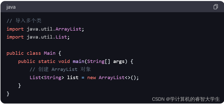
关键字:import关键字
在 Java 中,import关键字用于导入类或接口,使你可以在代码中使用它们而无需完全限定其名称。以下是使用import关键字的示例代码: 在上述示例中,通过使用import关键字导入了java.util.ArrayList类,这样就可以在代码中直…...

【C#】.net core 6.0 通过依赖注入注册和使用上下文服务
给自己一个目标,然后坚持一段时间,总会有收获和感悟! 请求上下文是指在 Web 应用程序中处理请求时,包含有关当前请求的各种信息的对象。这些信息包括请求的头部、身体、查询字符串、路由数据、用户身份验证信息以及其他与请求相关…...
)
攻防世界——echo-server(花指令)
查壳 elf Ubuntu系统写的,用kali运行会报错找到主函数,双击进入loc_80487C1不是很懂,看了大佬的说是花指令常见的花指令机器码 9A,E8,E9,EB 把垃圾数据用nop(0x90h)填充切换到汇编试图将loc_80487C1右键转换成未定义的数据对loc_80487C4进行c…...

GAIA-DataSet:构建智能运维研究的数据基石与算法验证平台
GAIA-DataSet:构建智能运维研究的数据基石与算法验证平台 【免费下载链接】GAIA-DataSet GAIA, with the full name Generic AIOps Atlas, is an overall dataset for analyzing operation problems such as anomaly detection, log analysis, fault localization, …...

办公自动化__简单日历工具
办公自动化__简单日历工具 一、概述用python编写的获取日历工具,输入年份并将在屏幕上打印全年12一个月,星期、日期、第几周对应关系。 利用到calendar、datetime、msvcrt三个库。 二、主要涉及思路 按照输入年份,循环使用clendar库显示日…...

AI代码库合规审计完整指南:5步自动化审查流程揭秘
AI代码库合规审计完整指南:5步自动化审查流程揭秘 【免费下载链接】Tutorial-Codebase-Knowledge Pocket Flow: Codebase to Tutorial 项目地址: https://gitcode.com/gh_mirrors/tu/Tutorial-Codebase-Knowledge 在当今快速发展的软件开发环境中,…...
)
保姆级教程:在Ubuntu 22.04上为LAMMPS编译ReaxFF+Kokkos+OpenMP混合加速包(含GPU/CPU架构识别)
在Ubuntu 22.04上为LAMMPS编译ReaxFFKokkosOpenMP混合加速包的完整指南 对于计算材料科学和分子动力学模拟的研究者来说,LAMMPS是一个不可或缺的工具。然而,当模拟系统变得复杂时,计算效率往往成为瓶颈。本文将详细介绍如何在Ubuntu 22.04系统…...

终极艾尔登法环性能优化工具:帧率解锁与视野扩展完全指南
终极艾尔登法环性能优化工具:帧率解锁与视野扩展完全指南 【免费下载链接】EldenRingFpsUnlockAndMore A small utility to remove frame rate limit, change FOV, add widescreen support and more for Elden Ring 项目地址: https://gitcode.com/gh_mirrors/el/…...

算法联盟·全域数学公理体系下黑洞标量毛发与LVK引力波O4全维理论、求导、证明、计算、验证、分析
算法联盟全域数学公理体系下黑洞标量毛发与LVK引力波O4全维理论、求导、证明、计算、验证、分析 算法联盟 全域数学公理体系下黑洞标量毛发与 LVK 引力波O4 全维理论、求导、证明、计算、验证、分析 所属体系:算法联盟 ROOT 全域数学网格第一性原理(AI科…...

Anthropic 推出面向小企业的 Claude:助力企业 AI 应用,拓展发展可能性
面向小企业推出 Claude2026 年 5 月 13 日,Anthropic 推出 [面向小企业的 Claude],这是一套含连接器和预运行工作流的解决方案,可将 Claude 集成到小企业依赖的工具中,助小企业主利用 AI 完成待办事项。小企业 AI 应用现状小企业贡…...

JAVA摄影约拍线上预约系统源码的预约流程
📸 JAVA摄影约拍线上预约系统 — 完整预约流程(源码级拆解)🗺️ 整体预约流程图(一张图看懂)用户端(小程序/H5) Java后端(Spring Boot) …...

AI编码助手选型与实战:从Awesome List到高效开发工作流
1. 项目概述:一个AI编码时代的“藏宝图”如果你最近也在关注AI如何改变编程这件事,那你大概率已经听过“AI编码助手”或者“AI结对编程”这些词了。从GitHub Copilot到各种开源的代码生成模型,工具层出不穷,但问题也随之而来&…...